
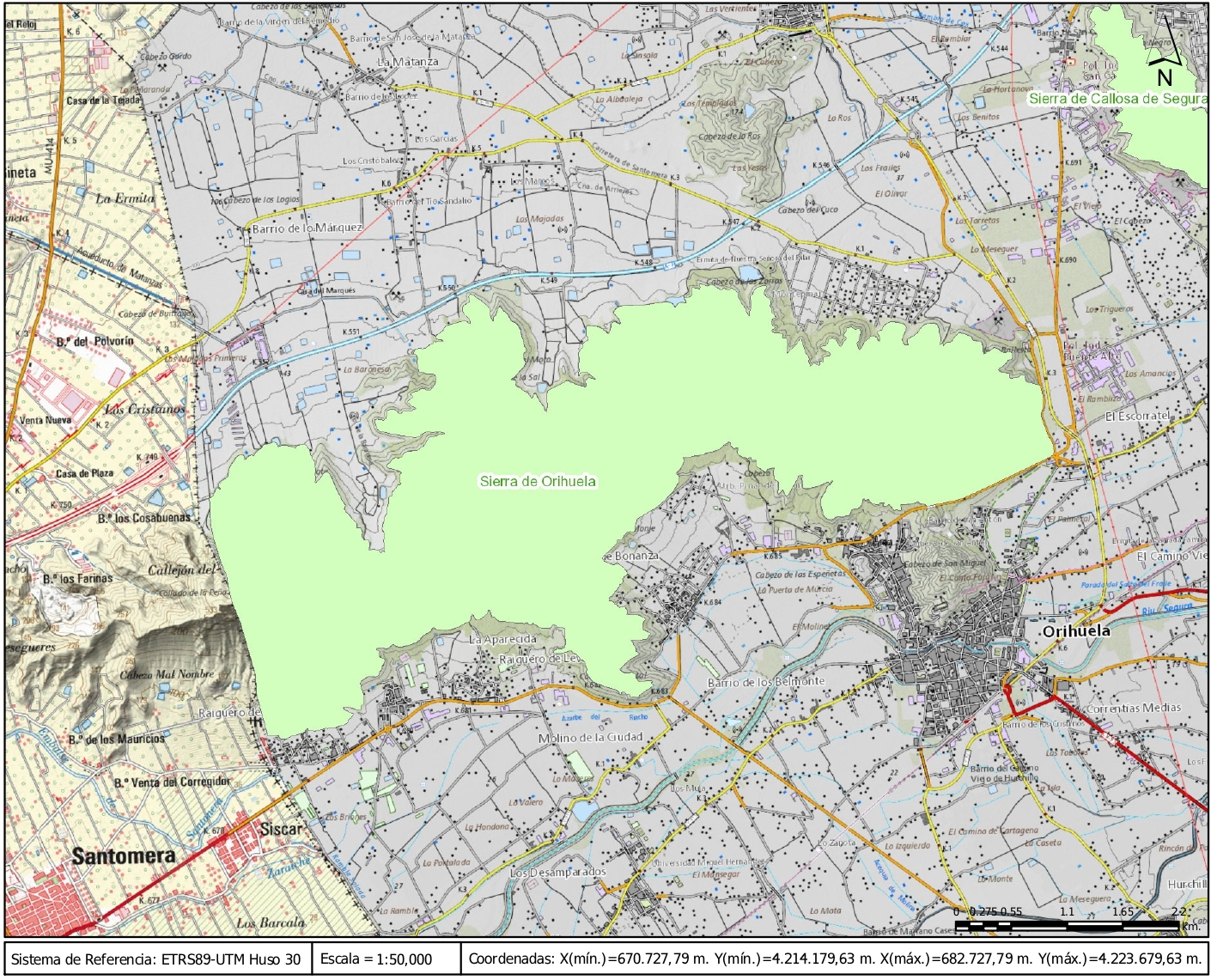
The Range Orihuela is a mountain range located between the southern limit of the province of Alicante and the eastern end of Murcia. It belongs to the Bajo Segura region, in particular to the municipalities of Orihuela and Santomera.
Orihuela is flanked by two landscapes of great contrasts, the Vega and the Sierra. The Sierra, which represents an essential part of the landscape of Orihuela and its inhabitants, was declared a Site of Community Interest (SCI) by the Generalitat Valenciana in 2002, including it in the Natura 2000 Network. In 1999 and 2005 two Flora micro-reserves (Rincon de Bonanza and Barranco de la Higuera-El Valle), and in 2009 it became part of a Special Protection Area for Birds (ZEPA). In addition to the recognized values for the fauna and flora, the value of its geological heritage, as occurs in the rest of the natural spaces of the Valencian Community, tends to go almost unnoticed. The Sierra de Orihuela has a varied and rich geodiversity that makes it a privileged place for activities for the dissemination and teaching of Geology. In the mountains and the surroundings of Orihuela you can see folds, hot springs and remains of old mining activities, or panoramic views of the Bajo Segura fault.
Sports activities such as hiking are growing considerably in the Sierra de Orihuela. Knowing the values ??of the Sierra and La Vega will help to value, if possible, its privileged natural environment.
Its moderate altitude, which does not exceed 634 m measured at its geodesic vertex located in Peña (Grief) Orihuela, does not prevent a steep orography that is difficult to access with extremely steep slopes, topped by narrow, stony valleys or deep ravines.
The close relationship that is established between the geological characteristics of its soils, the structure and composition of the plant and animal species that develop in them forces us to consider, even if only superficially, the different geological, lithological and geomorphological elements present in range mountain.
Located in the Zona Bética, the name by which the eastern end of the Cordillera Bética is known, the Sierra de Orihuela is an elongated and relatively narrow limestone massif, aligned from SW to NE. It is the only outcrop, next to the neighboring Sierra de Callosa, of these characteristics (alpine facies) in the entire Valencian Community. Its oldest materials date from the Permian (quartzites and slates), in the Paleozoic, although the most abundant are of Triassic origin (limestones), between 230 and 180 million years ago.
The presence of numerous faults and folds forms a rugged landscape of steep slopes with oriented slopes and highly variable insolation regime, which implies the existence of plant communities adapted to different environmental conditions according to their needs for light and humidity.
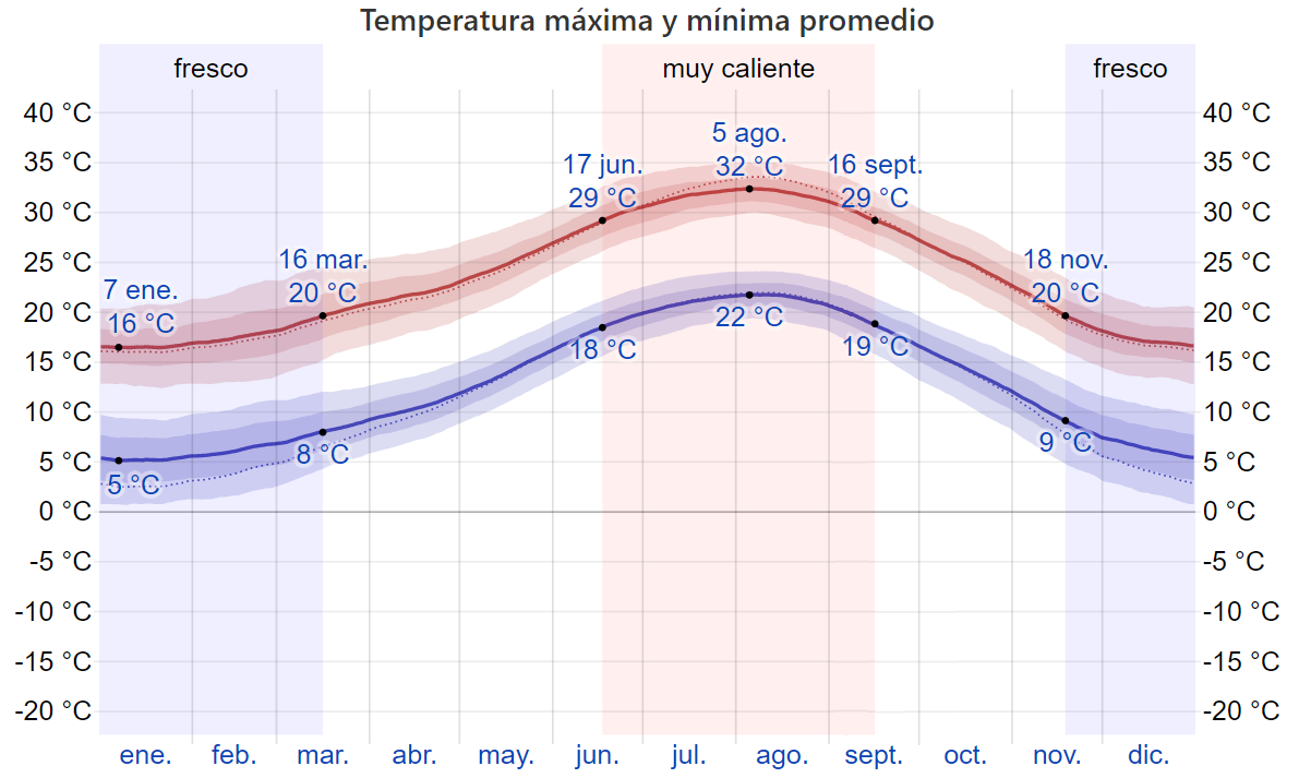
Orihuela's climate is typically Mediterranean, enjoying approximately 325 sunny days each year, reaching an average of 3,000 hours of sunshine per year and an average temperature that easily exceeds 20 degrees in the municipal area.
The proximity of the Mediterranean Sea and the layout of the N-S coastline mean that there is a fairly notable predominance of the easterly wind, although the sea breeze system causes the wind direction to be variable. This variability marks as general guidelines the predominance of winds coming from the west (wind from the West related to the atmospheric circulation of mid-latitudes) or from the Northwest in winter, and from the east and southeast in summer, reinforced by sea breezes.
Summers are usually hot with little to no rain. Temperatures range from 25 degrees Celsius to 35 degrees Celsius during the day. Temperatures at night rarely drop below 15 degrees Celsius.
In winter the climate in the municipality is very mild, with most days being clear and sunny with little rainfall. Temperatures can vary greatly in winter, going from one day to the next from 20 degrees Celsius to 6 degrees Celsius, causing a very cold thermal sensation due to the high humidity in the area.
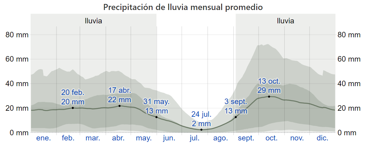
In autumn there is a rainfall peak, where October is the rainiest month. These rains can be torrential in nature and cause flooding, due to the fact that at this time of year the Levante storms coincide with a large storage of heat energy in seawater. The humidity of the wind flows and the thermoconnective energy contributed by the sea to the atmosphere is potentially high, which means that the episodes of falls detached in height (popularly known as cold drops) have their most spectacular effects in these months. This fact causes the appearance of heavy rain concentrated in a short space of time, with the risk that this entails for the flooding of the main collector of the region, the Segura river.
In spring, especially from mid-March, there may be cloudy days with a chance of some rain, being very variable and alternating clear and sunny days. The nights can still be quite cool until the end of April.
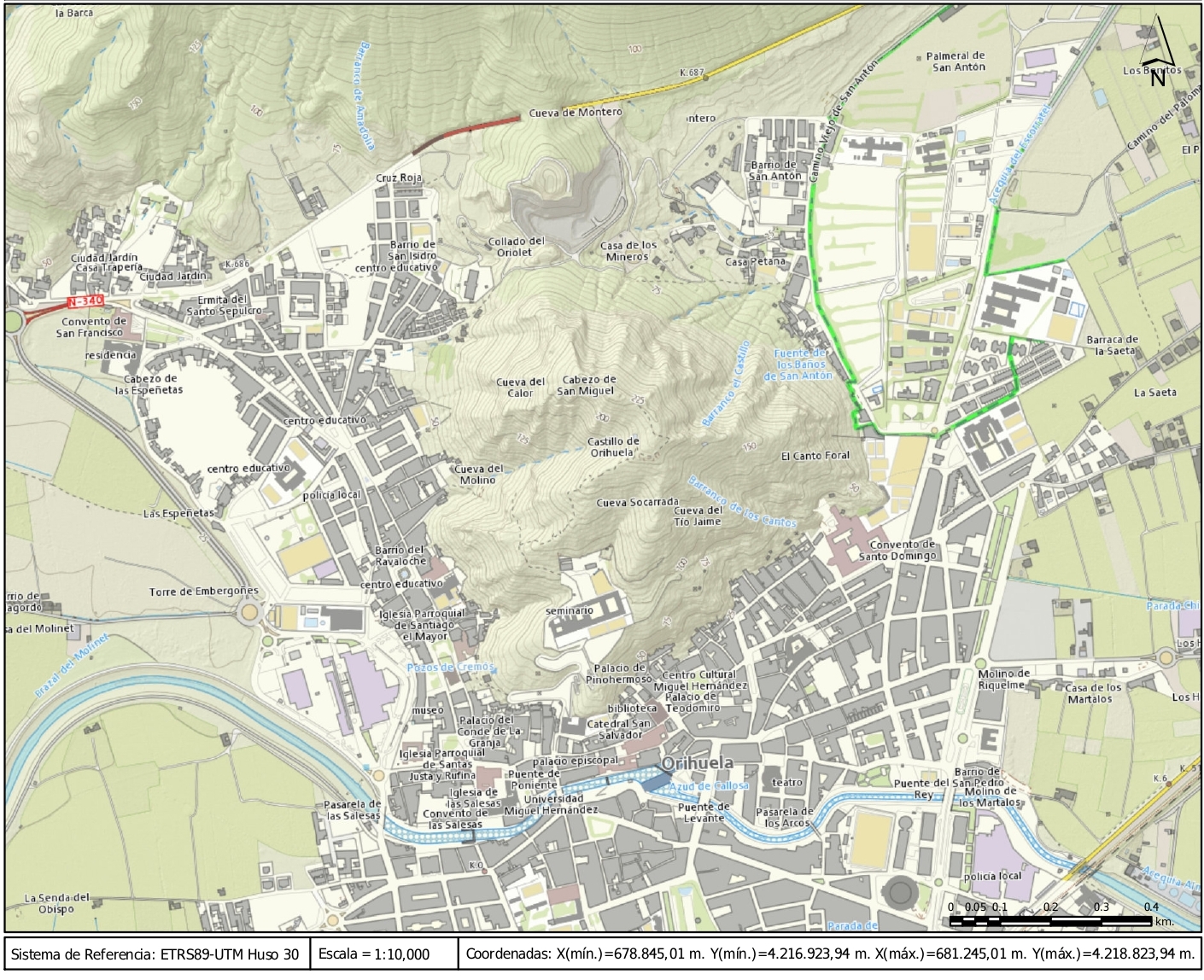
Mount whose highest peak is close to 250 meters high, located in the front-south part of the Sierra de Orihuela. It is a limestone massif that has cavities, caves and shelters distributed throughout its surface. The so-called "Cueva del Calor" (Cave of heat) stands out for its length, currently with a very narrow entrance due to overhangs and collapses of limestone blocks, and which, with its several hundred meters long, is said to have descended from the top of Monte de San Miguel to the base of the Range, in the vicinity of the Segura river.
It is linked to the Orihuela's Mountain Range by a small mound or hill called Cerro (hill) of Oriolet.
At its top are the ruins of the castle of Orihuela and on a lower plain, the Diocesan Seminary of San Miguel.
At the foot of this mountain there were the old thermal baths of San Antón, in the neighborhood of the same name, which are fed by an underground spring that runs under Mount San Miguel, whose geothermal character is manifested when it emerges on the surface with a temperature close to 25 °C. The high salinity of this water prevents its consumption, and it was used for the use of the spa and the irrigation of the nearby Orihuela palm grove.
The layout of the mountain has irremediably marked the urban layout of the city of Orihuela, being one of the most important geographical landmarks next to the Segura river itself.
Tel. 96.607.61.00 Ext. 3400
Tel. 96.673.77.20
email: deportes@orihuela.es
Departamento de Administración
Tel. 611.986.082
email: administracionorihuela@aossa.es
Tel. 96.607.61.00 Ext. 3411
email: deporteescolar@orihuela.es
CDM Playas de Orihuela
Tel. 603.749.826
email: recepcionorihuela@serveo.com