
If you want to view the route on a mobile device, scan the following QR code.


If you wish to download the map in PDF format at a scale of 1:20,000, click on the image.
If you wish to download the Track of the Tour in GPX format, click here.
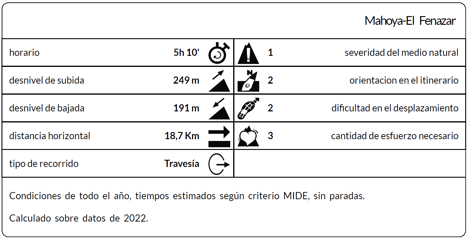
*The coding used for the assessment table of the difficulty in the route is the following:
Severity of the natural environment.
- The medium is not without risk.
- There is more than one risk factor.
- There are several risk factors.
- There are quite a few risk factors.
- There are many risk factors.
Orientation in the itinerary.
- Well defined paths and junctions.
- Trails or signage indicating continuity.
- It requires the precise identification of geographical accidents and cardinal points.
- Demands off-trace navigation.
- Navigation interrupted by obstacles that must be skirted.
Difficulty in displacement.
- Walking on a smooth surface.
- Walk along bridle paths.
- March on staggered paths or uneven terrain.
- It is necessary to use the hands or jumps to maintain balance.
- Requires the use of hands for progression.
Amount of effort required (calculated according to MIDE criteria for an average hiker lightly loaded).
- Up to 1 hour of effective walking.
- Between 1 h and 3 h of effective walking.
- Between 3 and 6 hours of actual walking.
- Between 6 and 10 hours of actual walking.
- More than 10 h of effective walking.
Concejalía de Deportes
Tel. 96.607.61.00 Ext. 3400
Tel. 96.673.77.20
email: deportes@orihuela.es
Departamento de Administración
Tel. 611.986.082
email: administracionorihuela@aossa.es
Tel. 96.607.61.00 Ext. 3400
Tel. 96.673.77.20
email: deportes@orihuela.es
Departamento de Administración
Tel. 611.986.082
email: administracionorihuela@aossa.es
Área de Deporte Escolar
Tel. 96.607.61.00 Ext. 3411
email: deporteescolar@orihuela.es
CDM Playas de Orihuela
Tel. 603.749.826
email: recepcionorihuela@serveo.com
Tel. 96.607.61.00 Ext. 3411
email: deporteescolar@orihuela.es
CDM Playas de Orihuela
Tel. 603.749.826
email: recepcionorihuela@serveo.com