
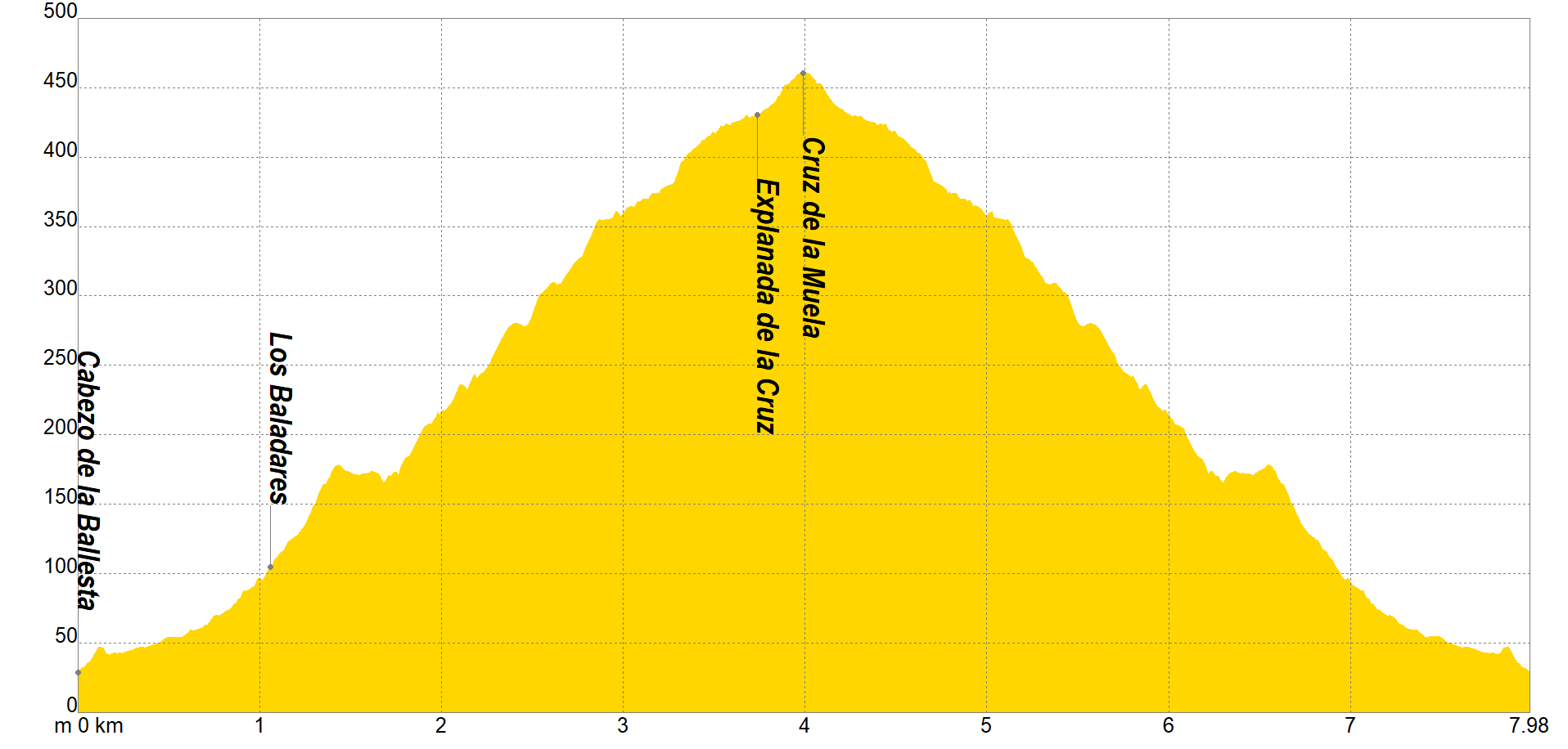
Without a doubt, this is the most traveled itinerary in our range, as it is a journey where every week hundreds of people pass through its 4 km of ascent starting from the Urbanization of Montepinar, a start that will soon be modified as it passes through privately owned plots.
The new proposal starts from "Cabezo de la Ballesta", next to the Oriokart karting circuit on the CV-870, ascending slightly to continue, next to various farms, until we enter next to the "Los Baladares" ravine, bordering it and later crossing it to the junction with a track, moving to an ascending path towards some zig-zags.
Without leaving our path, and after approximately 45 minutes, we will see the famous Cruz de La Muela (463 masl) which we can access from the "Explanada", where the views will invite us to have a bite and hydrate ourselves, being able to contemplate with a view Panoramic even the sea on sunny days.
The descent will be our next objective, returning to the starting point, retaking our steps, and taking care in the most eroded areas, where the rains and the great movement of people have made a dent in its firm.
Once we are back in the Cabezo de la Ballesta our route will have come to an end, becoming a route suitable for the whole family that must be traveled at least once in a lifetime.
If you want to view the route on a mobile device, scan the following QR code.


If you wish to download the map in PDF format at a scale of 1:10,000, click on the image.
If you wish to download the Track of the Tour in GPX format, click here.
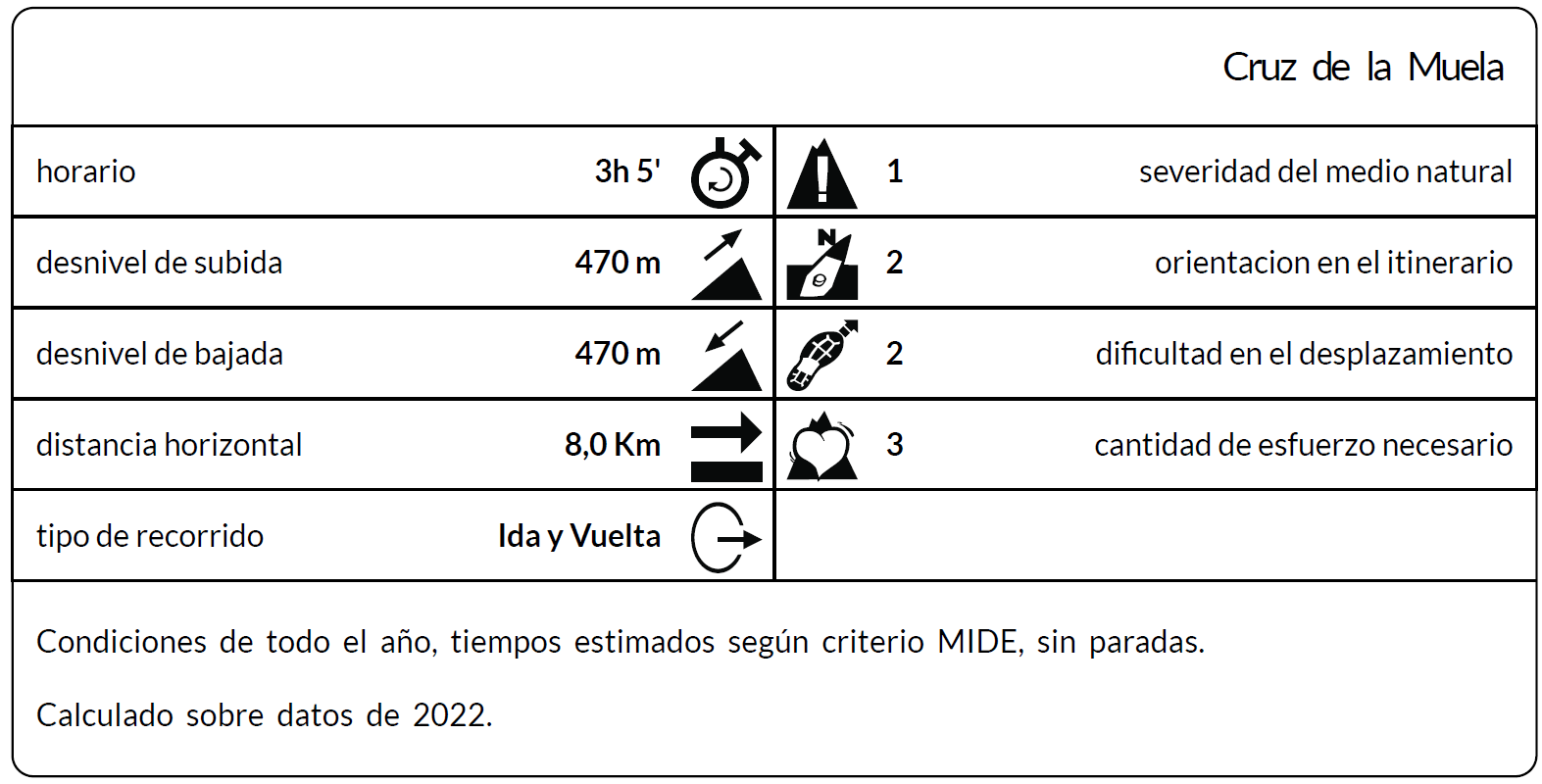
*The coding used for the assessment table of the difficulty in the route is the following:
Severity of the natural environment.
- The medium is not without risks.
- There is more than one risk factor.
- There are several risk factors.
- There are quite a few risk factors.
- There are many risk factors.
Orientation in the itinerary.
- Well defined paths and junctions.
- Trails or signage indicating continuity.
- It requires the precise identification of geographical accidents and cardinal points.
- Demands off-trace navigation.
- Navigation interrupted by obstacles that must be skirted.
Difficulty in displacement.
- Walking on a smooth surface.
- Walk along bridle paths.
- March on staggered paths or uneven terrain.
- It is necessary to use the hands or jumps to maintain balance.
- Requires the use of hands for progression.
Amount of effort required (calculated according to MIDE criteria for an average hiker lightly loaded).
- Up to 1 hour of effective walking.
- Between 1 h and 3 h of effective walking.
- Between 3 and 6 hours of actual walking.
- Between 6 and 10 hours of actual walking.
- More than 10 h of effective walking.
Tel. 96.607.61.00 Ext. 3400
Tel. 96.673.77.20
email: deportes@orihuela.es
Departamento de Administración
Tel. 611.986.082
email: administracionorihuela@aossa.es
Tel. 96.607.61.00 Ext. 3411
email: deporteescolar@orihuela.es
CDM Playas de Orihuela
Tel. 603.749.826
email: recepcionorihuela@serveo.com