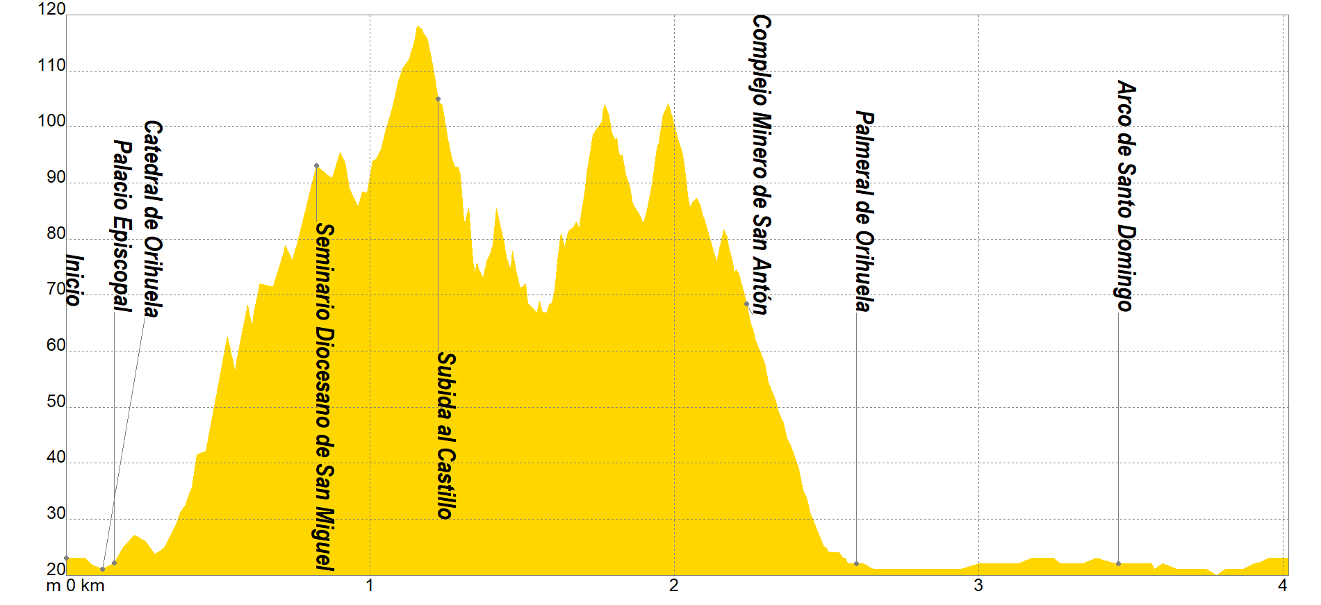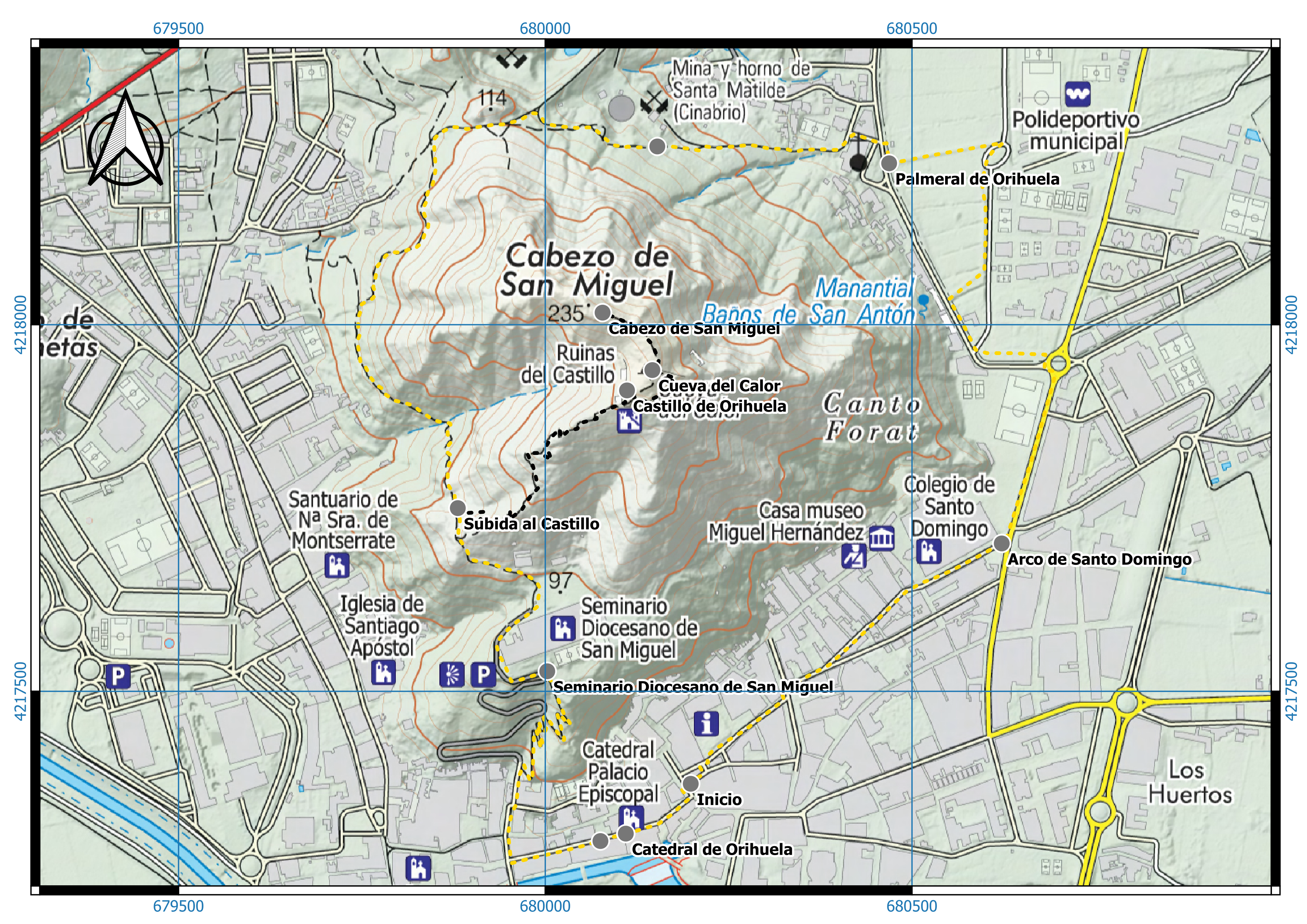
The tour begins next to the Tourist Office on "Calle Soleres", to head down "Calle Mayor de Ramón y Cajal", passing by the impressive Cathedral of Orihuela and the Episcopal Palace, to "Calle Colón Zen", which will be the moment in which We will begin with the ascent to the seminary through a pleasant cobbled section with spectacular views of our city.
Once we arrive at the Seminary, the route changes direction through a mountain terrain in a northerly direction, taking the detour up Mount San Miguel after 400 meters, at the top of which are the ruins of the Orihuela castle. Nearing 250 m above sea level, it is a limestone massif that has cavities, caves and shelters distributed throughout its surface, highlighting the so-called “Cueva del Calor” due to its length, currently with a very narrow entrance by collapses and landslides, where it is said that the cavity descended to the base of the Range, in the vicinity of the Segura river.
If we continue bordering the Monte, now with views of the steep walls of the southern face of the Orihuela's Mountain Range, we will arrive at the San Anton Mining Complex, which dates from the end of the 19th century. The Santa Matilde kiln, named after the Virgen del Carmen Mining Society, its owner, was inaugurated on March 5, 1888, constituting an important event attended, in addition to its owners, by journalists, politicians and clergy. It was only in operation for a few years, since the operation would close at the beginning of the 20th century. Due to a series of problems, the mining company, with capital from Alicante, went bankrupt, leading many people to ruin.
After going to the Barrio de San Antón, where there were old thermal baths that were fed by an underground spring that runs under Mount San Miguel, whose geothermal character is manifested when it emerges on the surface with a temperature close to 25 °C, we will enter in the Palmeral de Orihuela, the second largest in Europe with more than 600,000 m2, a place declared an Asset of Cultural Interest (BIC).
Continuing along Dr. García Rogel Avenue we will arrive at the Santo Domingo Arch and continue along Adolfo Clavarana and Santa Lucía Streets to Dr. Jose Maria Sarget Street, where this itinerary of great historical value will end.
If you want to view the route on a mobile device, scan the following QR code.
If you wish to download the map in PDF format at a scale of 1:6,000, click on the image.
If you wish to download the Track of the Tour in GPX format, click here.

*The coding used for the assessment table of the difficulty in the route is the following:
Severity of the natural environment.
- The medium is not without risk.
- There is more than one risk factor.
- There are several risk factors.
- There are quite a few risk factors.
- There are many risk factors.
Orientation in the itinerary.
- Well defined paths and junctions.
- Trails or signage indicating continuity.
- It requires the precise identification of geographical accidents and cardinal points.
- Demands off-trace navigation.
- Navigation interrupted by obstacles that must be skirted.
Difficulty in displacement.
- Walking on a smooth surface.
- Walk along bridle paths.
- March on staggered paths or uneven terrain.
- It is necessary to use the hands or jumps to maintain balance.
- Requires the use of hands for progression.
Amount of effort required (calculated according to MIDE criteria for an average hiker lightly loaded).
- Up to 1 hour of effective walking.
- Between 1 h and 3 h of effective walking.
- Between 3 and 6 hours of actual walking.
- Between 6 and 10 hours of actual walking.
- More than 10 h of effective walking.
Tel. 96.607.61.00 Ext. 3400
Tel. 96.673.77.20
email: deportes@orihuela.es
Departamento de Administración
Tel. 611.986.082
email: administracionorihuela@aossa.es
Tel. 96.607.61.00 Ext. 3411
email: deporteescolar@orihuela.es
CDM Playas de Orihuela
Tel. 603.749.826
email: recepcionorihuela@serveo.com

